One Day in Capitol Reef
The quietest of Utah’s Mighty 5, and the only one where you can pick fruit in an orchard. One day genuinely covers it — here’s the order that works.
One day is enough — and that’s not a compromise.
Most people arrive at Capitol Reef partway through a Highway 12 road trip between Bryce and Moab, and the honest answer to “how long do I need” is one full day.
The Fruita district holds nearly everything visitors come for: a paved eight-mile scenic drive, four or five trailheads, a historic orchard you can pick fruit in, and a pioneer homestead that sells pie. It’s compact in a way Zion and Arches are not.
What one day doesn’t get you is the backcountry — Cathedral Valley and the Waterpocket Fold need a second day and a high-clearance vehicle.
Do you have to pay to visit Capitol Reef?
It depends where you drive. The self-pay fee station sits on the Scenic Drive, just south of Fruita Campground. Highway 24 runs straight through the park and does not pass it.
So you can drive Highway 24, stop at the visitor center, walk to Hickman Bridge, see the petroglyph panel and visit the Fruita orchards without going through the fee station. Drive the Scenic Drive and you pay $20 per private vehicle.
Worth being precise about, though: NPS’s own pages differ. The Roads page describes the $20 as a Scenic Drive fee; the current Fees & Passes page describes it as a park entrance fee and says passholders must be able to show a pass on request. We’re telling you where the booth physically is — not advising you to skip a fee.
Last verified: September 2026 — recheck before you travelBefore You Go
- No reservation or timed entry. NPS states plainly that none is needed to enter Capitol Reef.
- $20 per private vehicle on the Scenic Drive. A Capitol Reef annual pass is $35, and America the Beautiful is accepted.
- Not in the Southeast Utah pass. That $55 pass covers Arches, Canyonlands, Natural Bridges and Hovenweep — Capitol Reef is not included.
- No $100 non-resident surcharge here. It applies at Zion and Bryce Canyon in 2026 but not at Capitol Reef.
- Nothing inside the park. No lodge, no restaurant, no fuel, and no cell service. Torrey is 11 miles west.
- Visitor center: 8:00 AM–4:30 PM daily, with shorter winter hours. Free Wi-Fi — the only Wi-Fi you’ll get.
- Trails start around 5,000 feet. NPS notes that even Easy-rated hikes feel harder if you’ve come from sea level.
Morning to Sunset
Start on Highway 24 and save the Scenic Drive for the middle of the day. The Hickman Bridge trailhead and the petroglyph panel are both off the highway, so you can be hiking at first light without stopping to pay anything — and the Scenic Drive is more pleasant once the morning chill has lifted.
Hickman Bridge
The signature hike, and the one to do before the day warms up. A natural bridge 133 feet across, reached by a climb up from the Fremont River and a short loop beneath the span.
The trailhead is on Highway 24, east of the visitor center. There’s no water here — carry your own.
1.8 mi round trip · 400 ft · Moderate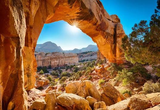
The petroglyph panel
Fremont rock art along Highway 24, reached by two wooden boardwalks. Wheelchair accessible, with parking for cars and RVs. NPS suggests five to thirty minutes depending on how long you look.
Boardwalk · Accessible · 5–30 minThe visitor center
Worth stopping even if you don’t need a map. It’s the only place in the park with Wi-Fi, there are flush toilets, and rangers will tell you what the backcountry roads are doing today — which changes constantly.
Free Wi-Fi · Open 8–4:30Fruita orchards & the Gifford House
The thing that makes Capitol Reef different from every other park in Utah. Historic orchards planted by Mormon settlers, and you can pick the fruit — apricots late June to mid-July, peaches late July to early September, pears early August to early September, apples mid-August to mid-October.
There’s a self-pay station with a scale at the orchard entrance. Fruit you eat inside the orchard is free. Fruit you take costs — currently $2.00 a pound, though the rate is set seasonally.
The Gifford House sells fruit pies, homemade ice cream and pioneer-era goods. Open March 14 to late November, 9 AM to 4:30 PM.
Ashley’s pickSeasonal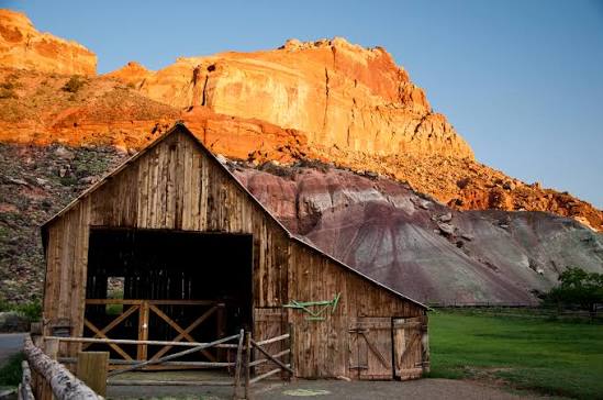
The Scenic Drive
7.9 miles one way, paved, and where the $20 is collected. It runs south along the base of the Waterpocket Fold with the cliffs rising the whole way.
It’s a dead end — you drive it out and back, and the two canyon spurs branch off it.
7.9 mi one way · Paved · $20Grand Wash
A flat walk up a canyon that narrows to a slot barely wider than your arms. Almost no elevation, and the easiest way to get inside the rock rather than looking at it.
Do not enter if storms are possible anywhere upstream. Vehicles were washed down this wash in a 2022 flood.
4.4 mi round trip · 200 ft · Easy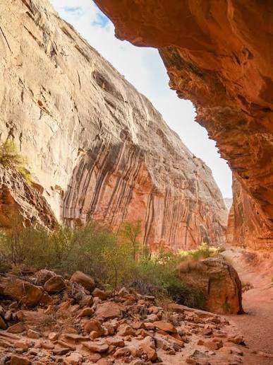
Capitol Gorge & the Tanks — or Cassidy Arch
Capitol Gorge is the easier option: a flat walk through a gorge past pioneer signatures carved into the wall, with a short scramble up to natural water pockets called the Tanks. 2 miles round trip, 80 feet.
Check current conditions before you count on Capitol Gorge. Both canyon spurs are dirt roads that close after storms, and NPS updates the road report weekly. If it’s shut, Cassidy Arch is the alternative.
Cassidy Arch is the hard one — 3.4 miles round trip and 670 feet, rated strenuous, ending on top of an arch you can walk out onto. Named for Butch Cassidy, who reportedly used this country to hide in.
2 mi · Easyor 3.4 mi · Strenuous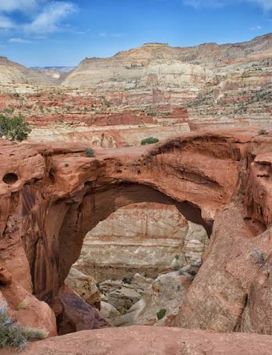
Panorama Point, the Goosenecks & Sunset Point
Back west on Highway 24. Panorama Point is a very short walk from its car park for a 360-degree view. From there a one-mile dirt road leads to the Goosenecks Overlook — a tenth of a mile from the car — looking down at Sulphur Creek a thousand feet below.
Sunset Point is the finish: 0.8 miles round trip, nearly flat, and the best light in the park lands on the Waterpocket Fold from here.
0.8 mi round trip · EasyBest photo spot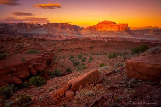
Highway 24 goes through the park for free. The fee station is on the Scenic Drive, south of the campground — which is why so many people are confused about whether they paid.”
| Trail | One way | Round trip | Elevation | NPS rating |
|---|---|---|---|---|
| Goosenecks | 0.1 mi | 0.2 mi | <50 ft | Easy |
| Sunset Point | 0.4 mi | 0.8 mi | <50 ft | Easy |
| Hickman Bridge | 0.9 mi | 1.8 mi | 400 ft | Moderate |
| Capitol Gorge / the Tanks | 1.0 mi | 2.0 mi | 80 ft | Easy |
| Cassidy Arch | 1.7 mi | 3.4 mi | 670 ft | Strenuous |
| Cohab Canyon | 1.7 mi | 3.4 mi | 440 ft | Moderate |
| Grand Wash | 2.2 mi | 4.4 mi | 200 ft | Easy |
| Rim Overlook | 2.3 mi | 4.6 mi | 1,110 ft | Strenuous |
| Chimney Rock Loop | — | 3.6 mi (loop) | 590 ft | Strenuous |
| Navajo Knobs | 4.7 mi | 9.4 mi | 1,620 ft | Strenuous |
NPS publishes Capitol Reef trail distances as one way, except Chimney Rock which is a loop. Round-trip figures here are doubled. A lot of guides quote the NPS number as if it were round trip — check which you’re reading.
Five things people get wrong here
1. The trail distances. NPS lists them one way. “Navajo Knobs, 4.7 miles” is actually a 9.4-mile day.
2. High clearance doesn’t mean passable. NPS warns that Cathedral Valley roads can defeat high-clearance 4WD after rain — the bentonite clay becomes unusable when wet, and the Hartnet route crosses the Fremont River with no bridge.
3. Flash floods don’t need rain overhead. Water can arrive in a canyon from storms many miles away, hours later. Clear sky above you means nothing.
4. The backcountry is genuinely remote. NPS tells Cathedral Valley visitors that help may take hours or days, and to carry extra water, food, fuel and a shovel.
5. “Easy” is relative to elevation. Trails start around 5,000 feet. NPS says its Easy hikes feel harder to visitors arriving from sea level.
Practical Notes
- Water: a year-round fill station at Fruita Campground, plus seasonal refills at the visitor center, Gifford House and the picnic area. Nothing at the trailheads.
- Restrooms: flush toilets year-round at Fruita Campground, at the visitor center during opening hours, and pit toilets at most trailheads.
- Fuel: none in the park. Torrey is 11 miles west, Hanksville 37 miles east.
- Best months: NPS points to March–June and September–October — good hiking weather, less chance of snow or monsoon storms.
- Flash flood season runs mid-June to mid-October, peaking July to September. Stay out of Grand Wash and Capitol Gorge when storms are around.
- Summer averages 87–91°F, cooler than Moab but with little shade and no trailhead water.
- Camping: Fruita has 71 sites, 65 reservable up to six months ahead at $25 a night. There are no first-come sites.
Doing the Mighty 5?
Capitol Reef is stop three, and the drive from Bryce along Scenic Byway 12 takes about three hours — one of the best roads in the country. Heading west, it’s Bryce Canyon and then Zion. Heading east, Arches & Canyonlands from a Moab base.